by Erin Surette
The Hellgate 100k++ is a 66.6-mile race on the Glenwood Horse trail in the Blue Ridge Mountains of Virginia. On paper (spoiler alert: also in reality), the race appears to contain all the predictors of a terrible race for yours truly: a midnight start, many miles, a lot of rocks, and a lot of descent. On rocks. Also, an extremely competitive field.
In 2014, when I first heard about this race, I laughed and said “how ridiculous” and “I’m never doing that” and “what does ++ mean?” In 2018, after a year of races I also swore I’d never do (including the Catoctin 50K and the Barkley Fall Classic), I figured Hellgate would make a fitting nadir to my 2018 racing season. So in October, I mailed in my paper application. The race committee selects 140 runners from all the applicants based on their previous race history; only those whom the committee believes to be able to complete the race under cutoff (18 hours) are selected. A few weeks later, I received an email telling me that I was accepted into the race. The gastrointestinal stress response was immediate. Having never raced longer than 50 miles, I’m not entirely sure why I was selected. But here we are. Thanks for taking a chance on me (I guess).
Race check-in started at 5 p.m. on Friday; James and I arrived at Camp Bethel, the check-in and finish location, right at 5 and went in to get my race number. I opted to skip the pre-race dinner and meeting in order to get a few hours of sleep before the race at my hotel; this proved to be maybe my only smart decision of the weekend. I ate dinner (an extremely mediocre pizza), and then slept until 10:30 p.m. At 11:15, we met up with two runners from the Philly area who were staying at the same hotel, Tom and Chrystal, and gave them a ride to the start. As we left the parking lot, a long line of cars passed the hotel— the race caravan, according to Tom. Sweet! We hopped onto the end of the line and followed the cars to the Big Hellgate parking lot, checked in with race director David Horton and then made our way to the yellow gate marking the start of the race. A few minutes before midnight, Dr. Horton led us in the singing of O Holy Night, followed by the Star-Spangled Banner. Then, at 12:01, we were off.
[I should mention that, in the days leading up to the race, there was talk of a major snowstorm hitting the area and coinciding with the race; luckily, the snow held off until Sunday morning. Race weather was pretty near perfect for early December: cold (down to about 18 degrees at the higher elevations), but not cornea-freezing cold, and no wind.]
[Note: the parenthetical mileage after each aid station is Horton’s advertised mileage followed by the actual mileage.]
The 4-ish miles to the first aid station were runnable double and single track, and uneventful. The water crossing was no biggie. Not long after the stream crossing, the trail came out to a gravel road where Aid Station (AS) 1 was located (3.5 miles/4.0 miles). The road was a lot of vert in a short amount of time: about 4 miles and 1200 feet of gain over several switchbacks. I didn’t mind this climb so much. It was runnable, I could see the trail of headlamps twinkling ahead and behind, and I chatted most of the way up with a Liberty University grad student named Lexi, who was the youngest person in the race at 22.
AS2, Petite’s Gap (7.5 miles/7.9 miles), was at the top of this climb. I saw James, grabbed a cup of Coke, and GTFO’d. We crossed the Blue Ridge Parkway and headed downhill on some twisty, technical single track. I was alone for most of this section, which I spent looking for a good spot to stop and pee, but then I never did because I was scared of bears. And it was REAL dark. I was also terrified of getting off course. Eventually the trail widened into grassy double track and Lexi caught back up to me. We chatted and leapfrogged back and forth for a bit. At this point, I was already struggling with nausea and taking in calories, and then worrying about the nausea again, which compounded the situation. It’s not something I’m good at. I nursed a gel for a few miles, then switched to a packet of baby food, which was slightly more palatable. As we climbed higher, a light dusting of snow appeared on the ground, which was fun. We turned onto some more technical single track, then popped back out for a gravel road climb up to AS3, Camping Gap (13.1 miles/14 miles). I don’t remember this aid station but I’m sure it was awesome.
Camping Gap to Headforemost Mountain (21.9 miles/23.8 miles) is one of the longer stretches between aid stations; Horton advertises it to be 8.8 miles but it’s closer to 10. Aside from the nausea, I felt okay for most of this section. The first half was grassy single track, mostly climbing up, and it was cool to look out and see all the lights down in the valley below. We made a left and went down the trail, which had a lot of turns and required constant vigilance. After this it was out onto the road again for a 700-800-foot climb up to the AS and first cutoff of the day (6:30 a.m, I think). I’m not sure what time I got there, as I was starting to unravel at this point, but it was about an hour before the cutoff.
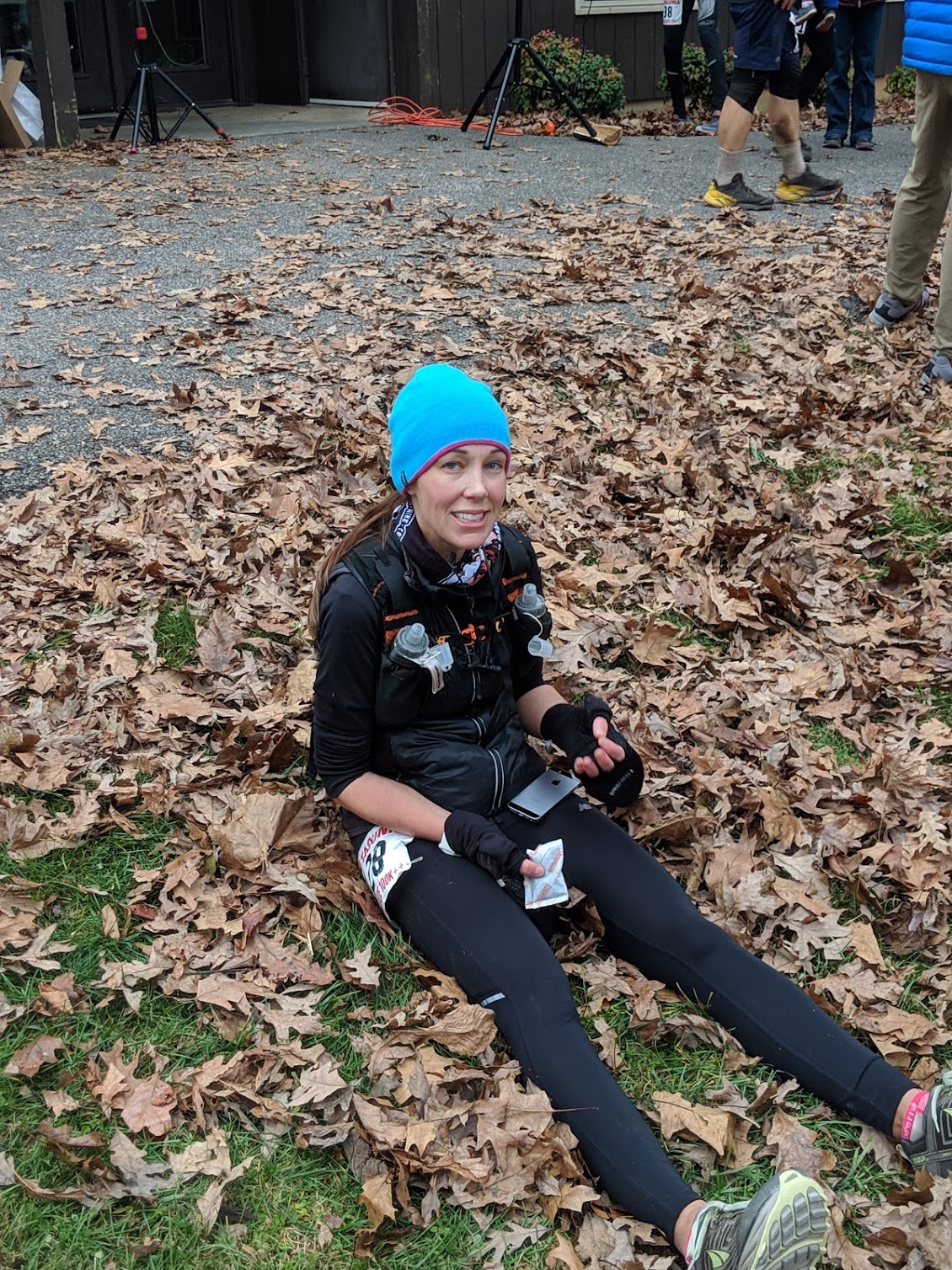
Tom and Chrystal caught me at this AS, along with another runner named Amy, so I tucked in behind them for around 6 miles of terrible ankle-twisting trail to Jennings Creek. This was probably a mistake, as they were moving well, and I was struggle-festing in the worst way. The best part about this section is there’s a stupid long downhill where, at the top, you can see the bonfire at the Jennings Creek AS, and it looks close, but joke’s on you, pal, because you basically wind around and get asymptotically closer to the AS for what feels like an eternity. During this downhill, I was too calorie-deficient to realize my headlamp was dying which was likely contributing to my inability to see a damn thing. I fell down. I cried. Cried so hard that I couldn’t even thank the trail angel who helped me up (thank you, kind sir, and sorry for being the worst).
When I came into Jennings Creek (27.6 miles/30.2 miles) and saw James, I cried some more and told him I was dropping, that I couldn’t do it, that I was DFL—it was a full-blown pity party. I’d had probably 200 calories at this point, so after a pep talk from J and several volunteers who have no doubt seen this scenario play out countless times and knew exactly what to say and were amazing, I took an Ensure for the road, shed my headlamp (since it was getting close to 7 a.m.), and walked away. Then I stood in the middle of the road until someone else came out of the aid station, because I was confused about which way to go.
As luck would have it, the next person who came out onto the road was fellow Baltimorean Emily Clay, who saved me for real. We hiked for awhile up yet another gravel road, chatting about work and life as the sun came up. In addition to the Ensure I grabbed at the last aid station, I had also taken some ginger candies at the suggestion of a volunteer, and both helped to get my nausea under control. Things were looking up! When you’re in the worst of it, it’s nearly impossible to remember that things don’t always get worse, but sometimes it’s true.
The forest in this section was eerie. A bad ice storm back in November did a lot of damage, and the trees were all twisted and snapped. Eventually we hit some more single track, then a gravel road, where James was waiting, no doubt because of how much of a mess I had been at Jennings. He reminded me to keep taking in calories as we ran by. Back onto some more trail, and then a 2-ish mile climb on gravel road up to the aid station at Little Cove Mountain (34.5/37.8), where we saw Lexi, who was struggling with nausea. Despite that, she seemed in good spirits and was moving well; she stayed with us for about 4 miles or so and then suddenly I realized she had dropped off. About a mile later, I stopped for an emergency poop situation (I had some baby wipes in my pack and man did they feel luxurious) and wished Emily well. She had warned me about this next section before the Bearwallow Gap aid station, and man—it sucked real hard. Imagine a narrow trail chiseled into the forest in a V-shaped rut. Then imagine that the point of the V is filled with loose, pointy, a-hole rocks the size of a softball. And then, to complete this foot-travel nightmare, the entire rut is filled with leaves. Every step is a mystery, but they’re all painful! Oh yeah and there were a lot of sharp switchbacks here but who cares because you’re walking anyway. Loser!
The next AS, Bearwallow Gap (42.5/46.5), was the second cutoff point of the day, which I think was 12:30 p.m., and I got there about 10:30-ish? Something like that. I’d be able to tell you exactly if my Garmin hadn’t died at mile 45. I can tell you that it felt much later; as that point I would have guessed it was close to 2 p.m. There was a ton of food here. Because I was still watching my caloric intake (eyeroll), I had three Saltines and a handful of grapes. I traded my empty Ensure bottle for a full one and James filled one of my soft flasks with Tailwind. It was a good decision. I left Bearwallow feeling…energetic? Motivated? Emily and I headed out and I felt good enough to run most (actually, maybe all) of the climb. Then I hit the “swoop” section of the course, which is several miles where the trail follows the ridgeline and swoops in and out of the mountain, with tremendous views of the valley. I loved this section so much. I was running, and it felt fast, and smooth, and I passed another six people. Life was good! I thought to myself that no matter what, I could run the rest of the way in, and make up some time, and then, yeah.
About 3 miles out from Bobblet’s Gap, I felt something pop behind my right knee, and then immediate pain. WHYYYY. Why is this happeninngggg to meeee. In my adrenaline-fueled state, however, I decided to do my best to ignore it. Remember when I cried and wanted to drop out? Yeah, me neither. I grabbed a stick to use as a makeshift trekking pole and hobbled my way up the climb into Bobblet’s (49.5/52.5). James seemed concerned, but I asked for a few ibuprofen, had a few more grapes, and got out of there. Just after leaving the aid station, I ran into another Amy, this one from Tennessee, and she was a total sweetheart. We slogged through most of the “forever” section together (more serpiginous, rocky single track) until she stopped to pee. I put on some tunes and forged on, eventually coming to a water crossing where a few intrepid volunteers had come to cheer, which was amazing.
I came into the last AS, Day Creek (56.1/60.5), where James informed me that a friend of his who had come through about 15 minutes ahead of me had pooped his pants, which made me feel better because hey, things CAN be worse. I don’t think I ate anything here. From Day Creek, it’s a 3 mile climb up to the Parkway, with a lot of false summits. It’s runnable, if that’s something you’re able to pull off. At the top, you cross over the parkway, and then it’s 2 miles down on gravel road and another mile on paved road to the finish. I got passed by a group of three dudes on the downhill and spent more time than I’d like to admit looking over my shoulder, but moved as fast as I could. I ran into the Camp, up the finish chute and across the line, and got a hug from Dr. Horton, who told me I looked like I had a lot left in me. Post-race pictures would suggest otherwise.
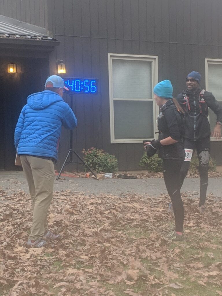
At the finish line with race director Dr. David Horton
Coming into this race, I thought I had zero chance of placing in the top 10. Even if I had a perfect race (LOL), and several others had terrible races, I didn’t think it would be possible. It was part of the reason I wanted to run it. I thought I’d be back of the pack; so did Dr. Horton, who seeded me 7th from last in the women’s field. But I did it. Somehow, I finished 10th, in 15:40. You know who was 10th male? Karl Meltzer. Yeah. WHAT DOES IT ALL MEAN? Nothing, really, but I’ll brag about it anyway. Actually, it means that Karl got a puffy coat and I didn’t, because gender inequality. Also I should run faster next time instead of whining.
A few days after the race I had an ultrasound of my leg; turns out I had a popliteal cyst that ruptured while I was running. Whoops. Pretty painful for a week or so, but it has mostly resolved, so that’s nice.
Have something to say? Leave a Comment


I ran my first Hellgate this year as well. Also my furthest race too! I think the top 10 for men and top 5 for women is reasonable since there are way more men than women that start the race. Otherwise, a quarter of women would get a jacket. Regardless, nice job out there and a very nice write up!
Congrats to you, too! I respectfully disagree with you about awarding overall male and female winners based on the number of participants. If you’re interested in reading a really great argument for why this practice sucks , Clare Gallagher wrote an excellent blog post re: the Vermont 100, a race that, like Hellgate, has a much higher percentage of male participants.